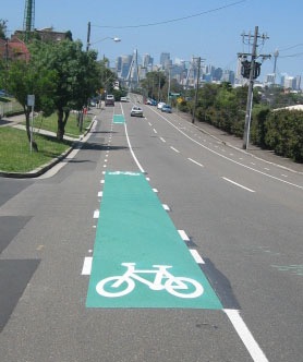
Transport for NSW in early 2016 moved to put in separated cycleway along the 2 km length of Lilyfield Rd. Lilyfield Rd would be part of a Regional Bicycle Route from Parramatta to the City. A number of plans have been prepared by consultants, and have been rejected or “put on hold”, mainly due to resident opposition and, in our view, lack of will by Council to promote a cycleway in the face of the opposition or “bike backlash”.
Lilyfield Rd Submission 23/3/18
Update March 6/2018: due to resident opposition the Council decided that the “project not proceed to design stage at this point” and that further work be carried out on the concept. More details at end of this page.
Update June 2019: A new consultant, Complete Urban, was appointed to have another go at developing a cycleway plan, with a timeline of about October for a first showing.
Update May 2022: A new plan was developed in 2019-20 but Covid and other problems with Westconnex works led to no implementation. Council says work may commence on the twice revised project in 22-23 . Funds (from TfNSW) are allocated in Budget. Work would only be from Hawthorne Canal to Balmain Rd, due to continuing uncertainties about Railyard Park connections. ]
Update November 2023: We were shown the plans for Lilyfield Rd as drawn by Complete Urban. There was discussion on various points but we were happy with the general plan, particularly west of Catherine St. Council engineers even made some constructive comments on making Lilyfield Rd safer for cyclists. We thought the plan would proceed between Hawthorne Canal and Catherine St, with the eastern section still to be finalised around the new Park.
We were badly surprised when we learnt In late 2023 the whole project has been “put on hold”, or even cancelled, despite funding being available and it being in the Works Schedule. There was talk of the need to fit the cycleway project into the new Rozelle Parklands (old Railyards) access plans, although it has been blindingly obvious for years where the access needs are, Whites Ck , Catherine St, Denison St, Cecily St, Gordon St, Johnston St etc. These were all outlined in the EIS for the Rozelle Interchange.
Update November 2024
Council briefed Complete Urban to do yet another revised plan, this time for a separated cycleway. At time of writing Council had received a plan but were seeking more details, such as loss of parking. Time frame for consultation with bike groups and community is early 2025, with a final concept plan and Council approval mid 2025. With luck it might be ready to submit for State Government funding in November 2025 and if successful, construction in 2026/27.
Masterplan for Rozelle Parklands.
Another reason given for delays in the Lilyfield Rd Project was the need to coordinate it with the Masterplan for The Rozelle Parklands, which amongst other things, calls for removal of on road bike lanes past the new Park frontage so angle parking can be inserted. They also propose changing the main path through the park to Anzac Bridge from a segregated path (pedestrians and cyclists separated by a white lane) to a shared path (no separation). Submissions were invited, closing January 31, 2025.
https://yoursay.innerwest.nsw.gov.au/rozelle-parklands-master-plan
Response to the Draft Masterplan by Bicycle NSW, IWBC, and other cycling groups has been against these changes, on the grounds they don’t encourage active transport or are not according to best practice, or research.
Bicycle NSW submission on the Masterplan
IWBC Submission
Other proposals in the Draft Masterplan, such as pedestrian and cycling crossings of Lilyfield Rd along the park frontage, and new bike lanes on Gordon St are supported.
Better wayfaring signage to and from the Park is needed, and all access routes to the Park should be identified and improvements made, like upgrading Whites Creek path.
History of the Cycleway.
A plan was first exhibited in November 2016 for comment. There was opposition from cyclists concerned with several aspects, and residents affected by loss of parking. After a year’s delay a revised concept plan was put on yoursayinnerwest.com.au and a final plan went to the InnerWest Council Traffic Committee and Council in February 2018. This approval was needed before detailed design could proceed.
The revised (December, 2017) plan widened the cycleway in places and proposed to make sections of the road one way. The latter was to provide extra road space so parking can be retained with a wider bike path, and also to reduce traffic on the road. This was opposed by many motoring residents, citing loss of convenience when returning to the precinct, for example by not being able to turn left onto Lilyfield Rd off Victoria Rd.
The stated aim of encouraging higher use by cyclists from the “interested but concerned” category remains questionable, given that the hilly nature of the road may be a more significant barrier to cycling use than perceived safety.
IWBC position was that there were some good aspects to the initial proposal, such as banning left turning traffic into Lilyfield Rd at Victoria Rd. This would lessen overall traffic on the road and make it much safer to access the footbridge. Residents with cars however were strongly opposed. a possible alternative was to allow left in but not the left out movement, i.e. make that section one way west.
The footbridge at Victoria Rd is a narrow and steep climb for cyclists. The Council pressured RMS to update the bridge, based on predicted growth in pedestrian traffic. It turned out though that plans in the EIS released in September 2017 for the Westconnex M4-M5 Extension show the footbridge being removed, to allow for an extra lane of traffic on Victoria Rd. Plans also show a path through the railyard and under Victoria Rd from about Justin St to join the Anzac Bridge approach east of Victoria Rd. [The footbridge over Victoria Rd was removed in 2022, forcing cyclists onto Gordon St. The other horseshoe footbridge, The Beattie Bush Bridge, was removed in 2022, severing the link between Robert St and The Crescent.]
Further planning for a park in the railyard as part of the Rozelle Interchange project was approved in 2019 and show bike paths through and across the Goods Yard, connecting with Anzac Bridge, Glebe and Annandale. Urban Growth (responsible for the redevelopment of the Bays Precinct) and TfNSW have also been looking at the options for direct links to White Bay and a repurposed Glebe Island Bridge. Cyclists could access the new park area at Justin St (access to the park is actually near Ryan St) east of Catherine St or at Denison St.
Previous calls by Bike Sydney for a bicycle link (City West Cycle Link) through the railway cutting under Balmain Rd and Norton St were rejected when the light rail was approved, but there are still hopes a tunnel (semi circular profile, chewed out from the rock wall of the cutting) next to the railway is feasible, or even a tunnel that does not involve the light rail cutting, which could start anywhere convenient, say near the foot of Lilyfield Rd. A local engineer said it was feasible technically, but would involve closing the light rail for a time. There will be a large amount of tunnelling equipment at the “dive sites” for the M4East-M5 tunnel. Also not known is if a way past the new light rail stabling and maintenance sidings at the eastern end of the cutting is possible.
IWBC wrote a letter to TfNSW about the use of the rail yard and the need for the CWCL. Inner West Council passed a motion supporting the CWCL in 2018. [Note in June 2019: little action on this front, it now appears that a tunnel is unlikely, as is finding a way past the light rail sheds.]
IWBC was opposed to the proposed use of a narrow two way cycle path on Lilyfield Rd down the steep hill from James St to Hawthorne Canal, and believes the present layout is the best option there (uphill bike lane, downhill share with traffic). The section between James St and Balmain Rd could have bike lanes on either side. Elsewhere a cycleway on one side (the south, where there are few side streets and is non-residential) may be acceptable, but needs to be wider.
The proposal does not fully take into account the wide unused footpath east of Balmain Rd next to the rail yard and only has a 2.4 m wide path, where 3 m would seem easily achievable. 3 m is the desirable width according to the Standards in Austroads publications. The revised plan shows they will need to relocate the kerb about 600mm anyway, plus move some power poles, so we have asked that a full 3 m or more path is provided from Balmain Rd to Justin St, where parking is to be retained, although we question this, since it is non residential. Council claims they have to provide parking for light rail patrons.
East of Justin St, to Gordon St, the proposal was to remove all parking on the non-residential side, so there is room for a wider bike path at 3.0 m, which we strongly support. Boats and trailers and heavy vehicles have been banned from parking there, and few residents park there, so we maintain our call for the unused parking lane next to the rail yard be used for a bike path or creation of bike lanes.
Note added 2/3/18: after considering some 1500 comments on the cycleway Council staff are now recommending that the project “not proceed to design stage at this point in time” due to resident backlash on the one way street restrictions. They will recommend that further work be done on the concept, but they wish to retain the bi directional path along Lilyfield Rd. They now favour a one way west set up from Victoria Rd to Gordon St, but still wish to retain the one way east between Norton St and Balmain Rd. See Traffic Committee Agenda (Supplementary) for 6/3/18 on the council website under Meetings.
23/3/18. We have Written to Council asking that they try to salvage the less contentious parts of the Lilyfield Rd project, but also recognise that other routes could be better in terms of getting new cyclists riding and also better at connecting to Main Streets and schools. We have suggested Lyall/Allen St from Darley Rd as an alternative, or “supplementary”, east west route, and also Canal Rd and Francis St to Allen St. This latter has a good gradient and connects back to Lilyfield Rd via Catherine St, or the Anzac Bridge via Brenan St and The Crescent. Longer, but a much better gradient.
The Mayor called a public meeting on the Cycleway on May 29, 2018, at Leichhardt Secondary College (Balmain Rd, Leichhardt). It was resolved to do a report on the failings of the cycleway project and also that the “supplementary routes” be investigated.
The M4East-M5 Motorway link was approved in March 2018 and the proposed pathway for cyclists in the Rozelle Railyards and under Victoria Rd also was approved. This was confirmed at a meeting with John Holland Joint Venture group, now in charge of the Rozelle Interchange project and the Goods Yard parkland project.
27/6/19. Council appointed a new consultant, Nathan Parish, from Complete Urban, to have another go at a cycleway plan for Lilyfield Rd. The “supplementary routes” will also be investigated.
RIC has walked away from the project, leaving many access problems unresolved. The yellow ramp debacle at Ryan St entrance typifies this. We put together a report on short term defects and longer term needs. See Google photo essay .
Another development of interest is the IWC proposal to make many more streets 40 K speed limited, or even 30 K. As members of Better Streets Australia we support lowering of urban speed limits and believe 30 is the best limit for safety- the chance of dying in a collision with a car is very low, substantially lower than 40. 30 is the norm in many other countries. Obviously arterial roads would be left at 50 or 60 if considered safe to do so. Lilyfield Rd and surrounding streets would be an ideal area for an Active Transport Zone, with great benefits for children and the elderly.
Photos of Lilyfield Rd on Google, over the years.
At the first Inner West Council Bicycle Working Group on June 16 it was stated that a “concept and design review” of the proposed Lilyfield Rd Cycleway would be held. A new consultancy to come up with a workable plan for Lilyfield Rd Cycleway project would be sought. Tender documents were being drawn up. RMS funding for the review would be available in 2018-19 FY. Funding for construction would be carried over to the next FY- not stated if this was guaranteed or would have to be sought.
Minutes of the BWG
The public meeting started with the Mayor saying that the current plan “was shelved”, and that a totally new approach was needed. He blamed the former Administrator for not progressing the project faster.
The alternative routes we proposed via Allen St were given support by the meeting, on a show of hands. Residents were still opposed to one way restrictions, particularly the one way east between Balmain Rd and Norton St. Some residents from the eastern end could see the merit of reducing traffic on Lilyfield Rd but most from the western end just wanted to maintain full access. No procedure for developing a new design was discussed, so the meeting left things hanging.
Meeting with the Greens tomorrow, to seek support for our alternative routes for new, or traffic shy, or less fit (or however you want to describe it) cyclists but also some less contentious improvements to Lilyfield Rd for experienced or fitter cyclists, which residents will be more likely to accept.
It turns out the traffic modelling was to examine the effects of making Lilyfield Rd one way between Norton St and Balmain Rd. Apparently they concluded it would not affect residents ability to access their homes. They will have to use Perry St or City West Link if heading west.
Latest news (September 24/2017) is that the revised plan, which we have not seen, is being scrutinised by RMS signals section, to see if the proposed cycleway will affect traffic flow at City West Link intersections.
The leichhardt Traffic Engineer was apparently unaware of the proposal by Westconnex in its M4-M5 extension EIS released in early September to run a path from Lilyfield Rd near Justin St through the railyard towards the Anzac Bridge, and to remove the footbridges at Victoria Rd to allow for more lanes for motor traffic. This would render almost half of the Lilyfield Rd cycleway redundant.